
The headache of street furniture inventories
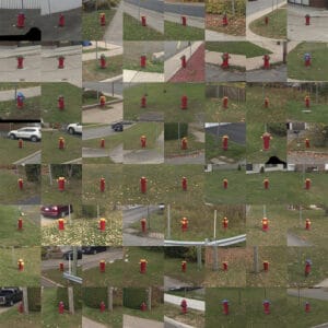
A park bench in Montreal has an average lifespan of 20 to 25 years, which varies according to events, bad weather, floods, vandalism… The inventory and updating of urban furniture databases is a real headache, as its definition is as broad as a geographical map. In fact, the Office québécois de la langue française defines street furniture as all public space equipment related to traffic, lighting, cleanliness, comfort and advertising. According to the City of Montreal by-law, there are no less than thirty categories of street furniture: trees, shrubs, benches, bollards, metro bollards, fire hydrants, geodesic bollards, marker posts, deceleration mounds, cables, valve chambers, fences, conduits, fountains, grates, lampposts, monuments, walls, low walls, signs, parking meters, poles, garbage cans, catch basins, manholes, receptacles for recyclable materials, manholes, street lights, pipes, vaults and other similar things of utility or ornamentation, placed by the city for its purposes.
For a city worker, taking inventory would mean criss-crossing every arrondissement to note the presence and condition of every public object.
But the headache doesn’t stop there. The sustainable development approach adopted by Montreal’s boroughs, which favours the repair and restoration of furniture rather than the use of traditional materials, is a good example of this approach. than its replacement, adds a new level of complexity to the task.
The qualitative inventory of street furniture is aimed primarily at reusing or repairing items, thus saving the borough money.
Furthermore, as priority is given to “problem” areas, where there are potholes, flooding, etc., city employees spend less time checking the condition of “regular” street furniture. The result is an incomplete, outdated inventory base that doesn’t always correspond to reality.
Jakarto has called on CRIM to create a system that will make the process of inventorying and tracking urban materials more efficient.

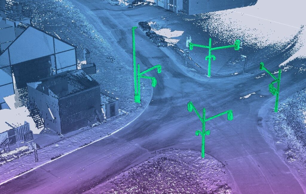
High-performance street furniture detection algorithms
CRIM has developed high-performance urban furniture detection algorithms based on the combination of data collected by Jakarto, namely 3D point clouds and high-resolution images. These data are positioned on the Earth’s surface using a state-of-the-art geolocation system. This solution, which will be integrated into the Jakarto platform later this year, can be used to build detailed city maps and locate objects with a high degree of precision.
CRIM made us aware of the challenges around data accuracy and the need to properly couple imagery and point clouds to locate certain types of street furniture objects.
– Loïc Messal, Scientific Director, Jakarto
CRIM’s expertise validated that there are shape models for street furniture that facilitate data collection in remote locations. The innovation saves city workers precious time, as they no longer have to make long journeys or wait for the snow to melt before continuing with the inventory. They can now concentrate on analyzing the inventory rather than collecting it. The effects are already being felt across the entire chain of activities, from maintenance work to urban planning.
Since then, many Quebec cities have requested detailed 3D map digitization on the Jakarto platform: the Vaudreuil-Soulanges RCM with its 2,000 km road network, as well as the City of Pointe-Claire for georeferenced 3D scanning of its 200 km road network.